


SityTrail - Unquera-Llanes

ZAMBAUX
User
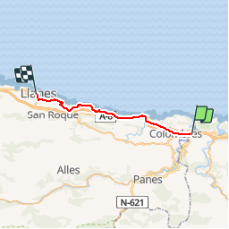

Length
25 km

Max alt
128 m

Uphill gradient
442 m
Km-Effort
31 km

Min alt
-1 m

Downhill gradient
433 m
Boucle
No
Creation date :
2019-05-09 15:36:01.486
Updated on :
2019-05-09 15:36:40.621
6h36
Difficulty : Very difficult

FREE GPS app for hiking
 SityTrail
IGN / Geographical institutes
SityTrail Plus
The world is yours!
About
Trail Walking of 25 km to be discovered at Cantabria, Cantabria, Val de San Vicente. This trail is proposed by ZAMBAUX.
Description
Ludres : Etape 4
Positioning
Country:
Spain
Region :
Cantabria
Department/Province :
Cantabria
Municipality :
Val de San Vicente
Location:
Unknown
Start:(Dec)
Start:(UTM)
377023 ; 4803512 (30T) N.
Comments